
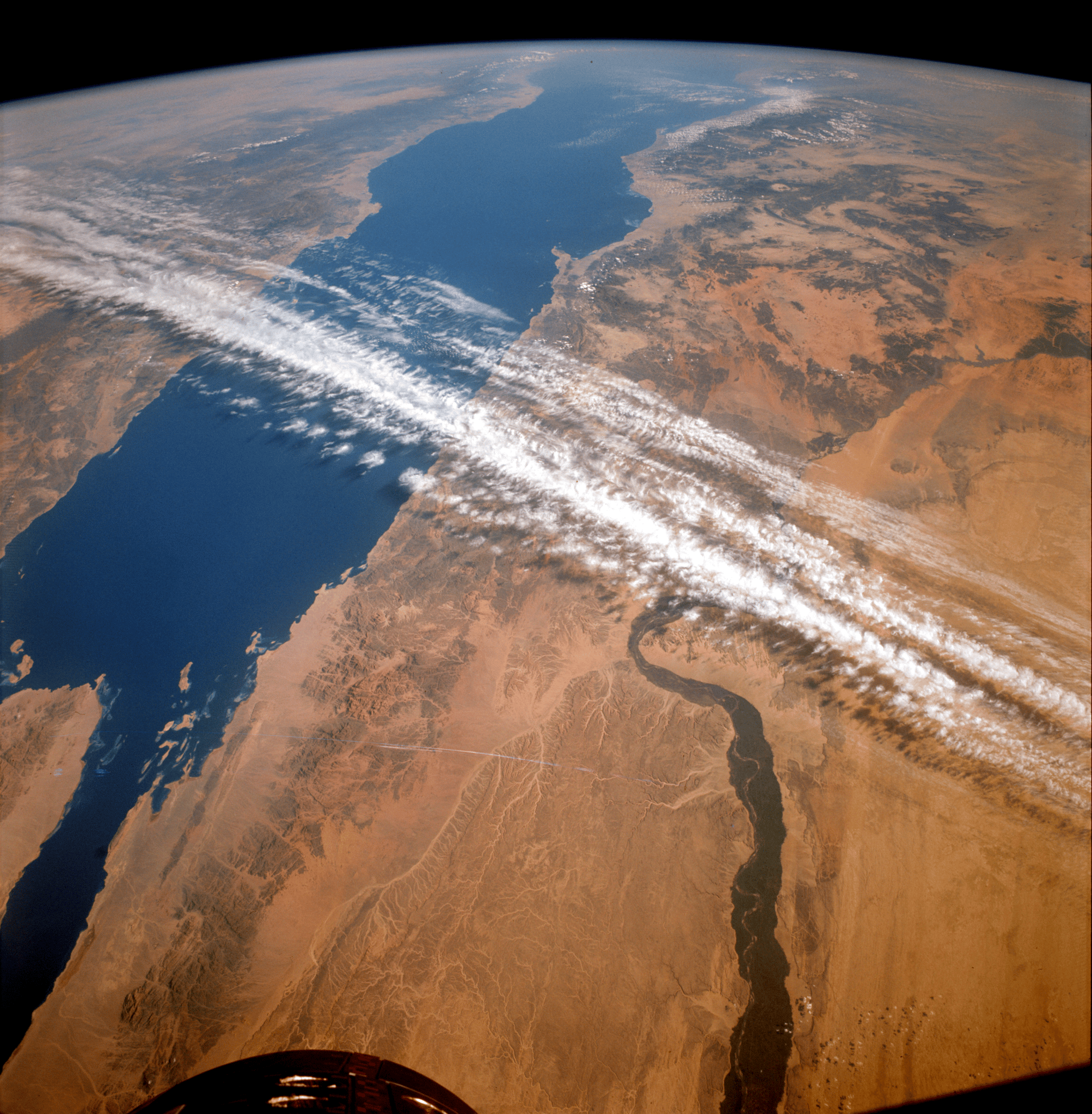
In November 1966, NASA’s Gemini XII mission placed astronauts James A. Lovell Jr. and Edwin E. “Buzz” Aldrin Jr. in orbit for four days, capturing a striking view of the Red Sea and Nile River valley. While the crew completed critical rendezvous maneuvers and spacewalks that paved the way for lunar travel, their photographs also sparked a new scientific ambition: using orbital imagery to study Earth’s surface. The images demonstrated the practical value of space‑based observation and helped launch a dedicated Earth‑resource satellite effort that would evolve into the modern Landsat program, a cornerstone of global environmental monitoring. Gemini XII marked the closing chapter of NASA’s Gemini program, launching on 11 November 1966 and returning on 15 November 1966 after four days in orbit. During that interval, astronauts James A. Lovell Jr. and Edwin E. “Buzz” Aldrin Jr. photographed the area surrounding the Red Sea and the Nile River valley on 14 November 1966, producing a clear, high‑altitude view of a historically rich landscape. In addition to the iconic image, the crew successfully performed rendezvous maneuvers and conducted spacewalks, procedures that proved essential for the forthcoming Apollo lunar landings. The mission’s visual records also illustrated how spaceflight could serve scientific observation, not merely exploration. NASA’s history notes that these photographs “demonstrated the value of orbital imagery for studying Earth’s surface” and helped spur a new field of exploration focused on observing Earth from space. The image became one of the earliest examples of using astronaut‑taken photos for scientific analysis. The striking Gemini photographs quickly attracted Earth scientists who saw their potential for resource studies. William T. Pecora, who served as director of the United States Geological Survey from 1965 to 1971, cited the Gemini and earlier Mercury images as a catalyst for a new satellite program. In a 1969 statement he explained that the Earth Resources Observation Satellite (EROS) program was “conceived in 1966 largely as a direct result of the demonstrated utility of Mercury and Gemini orbital photography to Earth resource studies.” Pecora’s advocacy linked the visual data from Gemini directly to the planning of a dedicated Earth‑observation satellite, providing the scientific justification that helped secure support for the program. This endorsement marked the transition from ad‑hoc astronaut photography to a systematic, satellite‑based approach for monitoring the planet’s resources. Guided by Pecora’s leadership, the Earth Resources Observation Satellite (EROS) program moved forward as a focused effort to place a dedicated imaging satellite in orbit. The program’s design built on lessons learned from Gemini’s ad‑hoc photography, emphasizing consistent global coverage, multispectral sensing, and reliable data transmission. Over time the EROS concept matured into the Landsat series, which provided the first operational Earth‑observing satellite capability. Landsat’s long‑term data record has become a foundational resource for scientists, policymakers, and land managers worldwide, enabling the tracking of surface changes across decades. NASA’s historical account notes that the Gemini images helped scientists make the case for this dedicated Earth observation effort, linking the early astronaut photographs to the eventual creation of a systematic satellite system that underpins modern environmental monitoring. The transition from astronaut snapshots to a continuous satellite record represented a pivotal shift in how humanity monitors its own planet. For more than five decades, Landsat and other Earth‑observing satellites have supplied invaluable data used around the world to monitor crops, wildfires, flooding, vegetation health, land use, and countless other changes to our planet. The continuity of the Landsat archive enables precise assessments of agricultural productivity, early detection of wildfire spread, and rapid response to flood events. Vegetation‑health indices derived from satellite spectra guide forest management and climate research, while land‑use maps support urban planning and conservation efforts. Because the data set spans multiple generations of sensors, scientists can compare conditions across time and detect long‑term trends such as desertification or coastal erosion. The legacy of the Gemini photographs thus endures, having transformed a brief visual experiment into a global system that underpins modern Earth stewardship and informs policy decisions worldwide.
Gemini Astronaut Photos Inspired Early Earth Observation Program
In November 1966, NASA’s Gemini XII mission placed astronauts James A. Lovell Jr. and Edwin E. “Buzz” Aldrin Jr. in orbit for four days, capturing a striking view of the Red Sea and Nile River valley. While the crew completed critical rendezvous maneuvers and spacewalks that paved the way for lunar travel, their photographs also sparked a new scientific ambition: using orbital imagery to study Earth’s surface. The images demonstrated the practical value of space‑based observation and helped launch a dedicated Earth‑resource satellite effort that would evolve into the modern Landsat program, a cornerstone of global environmental monitoring.

News Station Editorial Desk
We adhere to strict accuracy standards. Spotted a factual typo or outdated detail?

District News
News Station Editorial Desk
District News editorial team and global bureau correspondents.
Related Stories




Source Transparency & Verification
District TV Editorial Accountability
Coverage Comparison & Source Breadth
Editorial BreadthMulti-source editorial verification across national, wire, and local desks
Gemini Astronaut Photos Inspired Early Earth Observation Program
Latest Headlines
- 01CANADA
Roughriders Hitting Tough Spell at End of Season
- 02HEALTH
Pope Leo XIV's Brother Louis Prevost Also Battling Cancer, Wife Tells CBS News
- 03WORLD
Trump Says 'Massive' Oil, Gas and Mineral Exploration in Greenland Is 'Getting Ready to Begin'
- 04CANADA
12 Last-Minute Amazon Halloween Finds That Will Arrive on Time
- 05CANADA
Kelowna Residents Left with Costly Damage After Fuel Tanks Drilled
Join the Conversation
Moderated reader discussion · Community standards apply